The Sinai Peninsula photographed from the International Space Station, March 20, 2013. (Wikimedia Commons)
Can ten maps sum up the history of an ancient land mass? Moreover, can they tell us about the region's future? Determining where humans settle and where funds are invested in the Sinai Peninsula might sound like a contemporary argument ― but much of the answer lies in the cultural and archaeological landscapes of the peninsula.
To better understand the peninsula's complex geography with its multi-layered history, thousands of place names and points-of-interest are brought to the foreground on ten maps which mark human settlement and mobility patterns across the landscape over centuries.
The maps also tell the story of knowledge-making, which has fed into the minds of decision-makers, international planners and developers such as USAID, Britain's Foreign, Commonwealth & Development Office, the UN Development Program and the Food and Agriculture Organization, over the past four decades. The ten maps also help us assess published information, comprising more than 3,000 publications and reports, and locate critical gaps.
The ten maps are produced from the database of the 20-year survey by Sinai Peninsula Research (SPR) project. SPR's survey compromises more than 14,000 undocumented and published records across the entire peninsula, identified by place names or coded items (points-of-interest) along and outside the conventional routes and areas of interest.
SPR's field survey originally focused on the High Mountains of Sinai Peninsula but was extended to include the entire peninsula. Both mapped and unmapped information was transferred to SPR's extended geo-database.
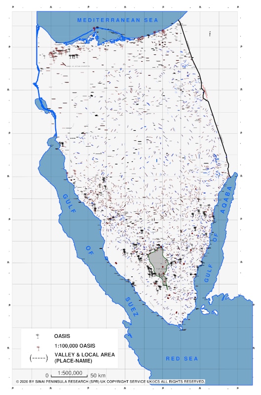
Physical geography is a conventional start point. The majority of the mountains with distinctive summits (landmarks), and place names accordingly, are located in the south, centered around Mount Sinai, and southwest. Gebel Katharina, at 2,642m above sea level (ASL), is the highest summit in the entire peninsula.
This is a contrast to Central and North Sinai, where the valleys are the major identifiers of the landscape. There are only a few isolated mountains in the centre-north and northeast, such as Ras El Gineina (1,626m ASL) above the el-Tih Plateau and Gebel Yalk (1,094m ASL). These tower over Central and North Sinai respectively. But what reality do these establish?
Map 1: physical geography ― mountain areas.
Policy thinking about Central and North Sinai, regions less defined by landmarks, tends to be more holistic compared to the South. There, in contrast, the understanding of landscape and development policy are overwhelmed by dense mountain landmarks separated by a complex and dense network of connecting valleys, which also act as boundaries.
Map 2: place-names (valleys and local areas).
El-Tih Plateau in central Sinai in the horizon (above 1,000m ASL) from the High Mountains of Sinai Peninsula (above 2,000m ASL), where the upland hills separate both regions (13 August 2015 by SPR).
Interestingly, small-scale remote sensing and mapping have become key tools for understanding both the less defined landmarks of the central and north Sinai, and the overwhelming landmarks of the south. But central government interest in developing a specific area often overwhelms local interests.
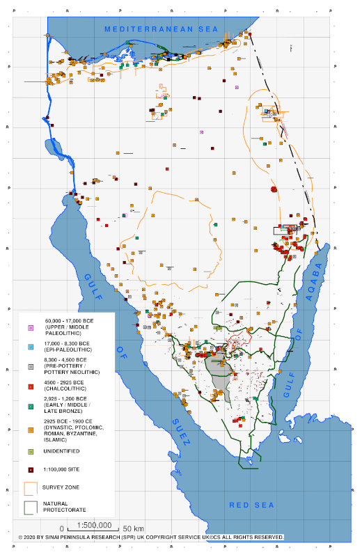
The archaeological knowledge, apart from partial motives, falls under four broad themes of complex and overlapping Egyptian and Near Eastern chronology and includes around 1,200 sites:
(a) Pre-historic Sinai from the Lower Paleolithic settlements to the Bronze Age;
(b) Egyptian Dynastic sites from the early 3rd millennium BCE through the Greco-Roman, Byzantine and Islamic periods;
(c) Biblical Sinai;
(d) Medieval (Islamic) and modern Sinai (7th century CE to present).
The Nabataean village of 'Gra el-Safha' (1st century CE) on the southern route to Petra (Darb El Batraa or Exodus Traditional Route) to the north of the High Mountains of Sinai Peninsula (21 September 2013 by SPR).
Many of these periods include fortresses, caravan routes, settlements, and industrial sites such as copper mines, as well as shrines and sacred landscapes.
The intersection between people, politics, and landscapes is also reflected in the map of modern Bedouin shrines. Some of the present Bedouin tribes migrated to Sinai Peninsula in the pre-Islamic era, namely, the Hamada and Gebaliya (6th century CE of Byzantine origin) tribes in the south, while the majority of the tribes migrated from Arabia to the peninsula between the 10th and 17th centuries CE. More than 40 Bedouin tribes formed alliances and battled over territories, resulting continuously changing boundaries.
Map 4: tribal territories and Bedouin shrines (Sheikh Tombs).
The Bedouin sheikh tomb of Sulieman Abu Khdraa and cemetery in the territory of 'Aliqat tribe (14th century CE) in Wadi Nasib in centre-southwest Sinai (24 July 2009 by SPR).
Today, the rights to rural and remote settlement, agriculture, water and even wage labour supply to development projects are argued between the tribes, clans and families. These disputes are communicated through different formal and customary channels, namely Sheikhs, to the local and regional authorities.
The landscape is dotted with more than 85 main Bedouin shrines, a Sufi-influenced tradition that kept the peninsula protected from the spread of radicalism in late 20th century CE. Terrorists targeted similar shrines in recent years.
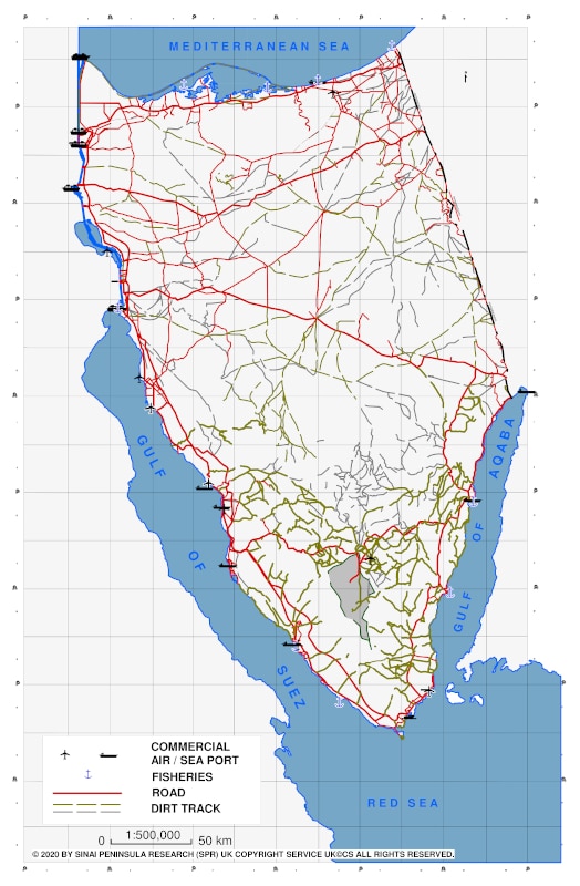
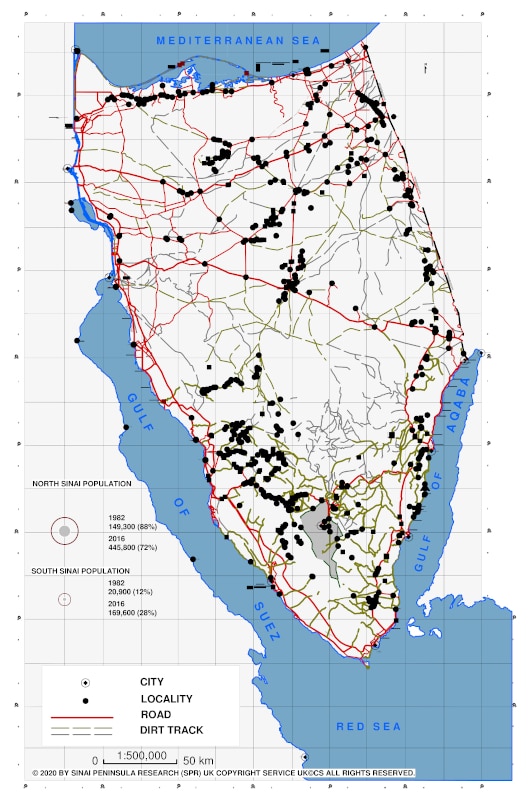
There is a vast history of trade, pilgrimage, travel, war, and development planning behind the ancient routes and desert tracks and roads network of the peninsula. It tells the past, present and future of Sinai. This complex network defines the accessibility and mobility across the land.
The El-Tih and el-'Igma plateaus with their extremely remote and dense valley tributaries act as a natural barrier in Central Sinai between the sand dunes in the north and the mountains in the south. While it is traversable, there is neither development nor security interest to make the central region more accessible nor a land bridge between north and south, apart from the connecting north-south coastal roads parallel to the Gulfs of Suez and Aqaba.
The network in the north was historically developed as a battlefield and later to serve development purposes. It has developed continuously since the British utilized it during World War I and later during the Egyptian-Israeli wars from 1948 to 1973, to allow the east-west mobility of troops.
In contrast, the network in the south was originally developed for economic purposes since early 20th century CE to connect the Nile with the mines and oilfields on the Gulf of Suez from the 1940s to the 1960s, and the tourism industry on the Gulf of Aqaba that was launched in the 1970s.
Map 5: road and dirt tracks network and air/sea ports .
Naqb Budra dirt-track in the manganese mining zone (20th century) of centre-southwest Sinai (4 September 2009 by SPR).
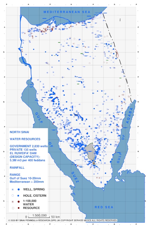
It would be misleading to assume that the concentration of water points (wells, springs, etc.) is an absolute indicator of quantity or quality. But it led to the emergence of remote Bedouin localities in mountain areas composed of several households each, made possible by seasonal husbandry activities based on ancient water harvesting techniques.
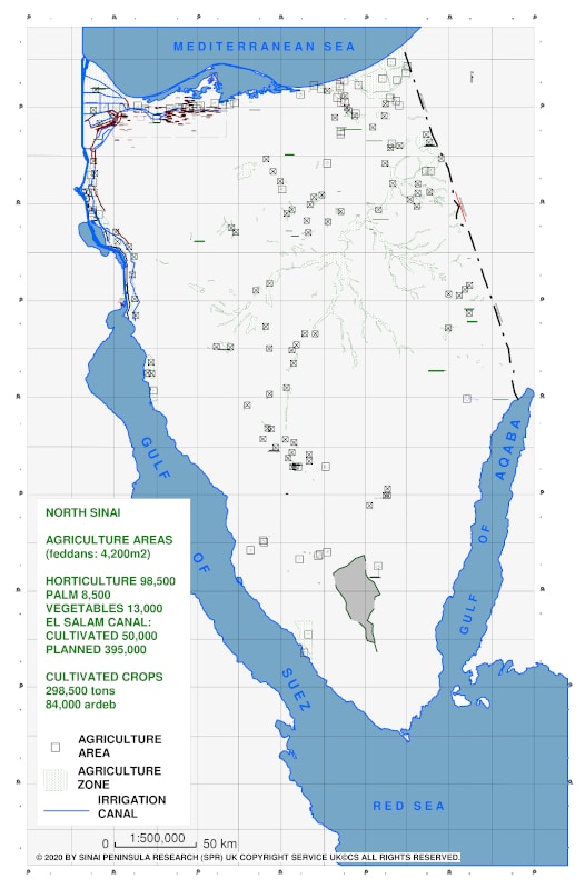
The El-Qa'a and el-Raha plains on the Gulf of Suez are the key agriculture exceptions in the south due to the availability of ground water. And again in contrast to the south, the largest yield comes from the ground reservoirs in the north supported by the highest average annual rainfall in the peninsula of 100 to 200mm on the Mediterranean coast. As a result, the Roman-Byzantine (30 BCE-640 CE) and later Islamic-modern (post 7th century CE) settlements pattern on the Mediterranean, and hundreds of Bedouin family agriculture plots and oases between the sand dunes, still mark the fertile lands.
But rainfall and reservoirs are not the only sources of water. Pellusim or Tell El Farma on the eastern edge of the El Tina plain and to the west of Suez Canal in the northwest of the peninsula marks the mouth of the extinct Pelusiac branch of the Nile and the fertile east delta plain. El-Tina and the northwest were connected with el-Salam Canal project in 1990s to bring the Nile water to the peninsula to irrigate agricultural land. The project first appeared in UN documents in early 1950s and on an Egyptian stamp in the 1960s.
Map 6: water resources (wells & springs) and rainfall belts.
Map 7: agricultural areas (permanent & seasonal).
Byzantine (4th-7th centuries CE) - Gebaliya Bedouin (pre-Islamic/contemporary) orchards at Wadi El Zuweitin and Naqb Gibal (8 Sep 2013 by SPR).
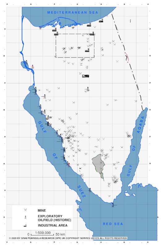
But exploiting resources on the peninsula is far older. Pre-historic and Dynastic copper mines and smelting furnaces were surveyed in the vicinity of the ancient mining zone in centre-southwest and in Wadi Riqeita in southeast Sinai. Today South Sinai and the inland vicinity of the Gulf of Suez export 4,000 tons/day of mineral deposits, metallic and non-metallic and building materials and ornamental stones.
The economic viability of the peninsula's coal and manganese deposits have had fluctuated over the past decades, but oil remains a staple. Gebel Hanka in the southwest was one of the earliest exploratory oilfields developed in 1910-1913, while many of the producing oilfields were developed in 1940s. The on and offshore oilfields of the Gulf of Suez have accounted for 60% of Egypt's total production in early 21st century.
Map 8: mining (oil & gas and minerals) and industrial areas.
But nothing better addresses the question of development policy- where humans settle and development funds are to be invested-than the distribution pattern of the existing cities, villages and localities and planned development areas.
Planned development (mostly public services) and accessibility continue to shape internal local Bedouin migrations, and eventually, inland depopulation in favour of the localities on the coast as the only livelihood choice.
The latter pattern is clear along the tourism development coast of the Gulf of Aqaba in the southeast, in contrast to the still considerable number of inland localities in the southwest, due to the lack of an expanding economy, and the partial reliance on sporadic mining and agriculture activities.
In contrast to the clear role of economic activities in South Sinai, accessibility has played the formative role in Central and North Sinai since 1980s. Localities are concentrated along roads and desert tracks network circling the upland rises, and in particular, to the west of the international boundary line. For centuries, North Sinai has been defined with its Mediterranean coastal road and agriculture activities with little change in its settlement pattern.
Map 9: cities, villages & localities and development areas.
The main Bedouin village of Hamada tribe (pre-Islamic period) in Wadi el-Lahian in centre-southwest Sinai and el-Tih Plateau in the horizon (30 August 2009 by SPR)
This pattern raises a question about Sinai's inland development and accessibility policies. While the lines of the demilitarized zones are a result of the peace treaty, the polygon-shaped administrative municipal boundaries across the peninsula remain one of the most unexplainable features in terms of 21st century governance. Part of the answer lies in the nature of the central government in Egypt, which retains a centralized approach which helps shape the patterns on all ten maps. In Sinai, as in many places, random patterns of governance and inconsistent development policy produce some of the strangest maps of all.
Map 10: administrative boundaries.
Ahmed Shams teaches in MA International Cultural Heritage Management (ICHM) at Durham University and is a research consultant at the School of Archaeology, University of Oxford (Endangered Archaeology in the Middle East and North Africa―EAMENA project).

.jpg)


No comments:
Post a Comment