Search This Blog

Friday, January 1, 2021

ANE TODAY - 202012 - OrientDams: The Impact of Dams on Cultural Heritage in the Middle East and North Africa -

http://www.asor.org/anetoday/2020/12/orientdams

OrientDams: The Impact of Dams on Cultural Heritage in the Middle East and North Africa

By Nicolò Marchetti and Federico Zaina


Dams and Archaeology in the Middle East and North Africa

Dams represent a controversial tool for economic development. Less contested is their impact on archaeological and heritage resources.

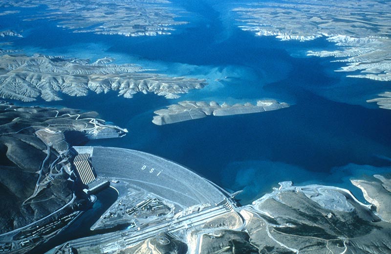
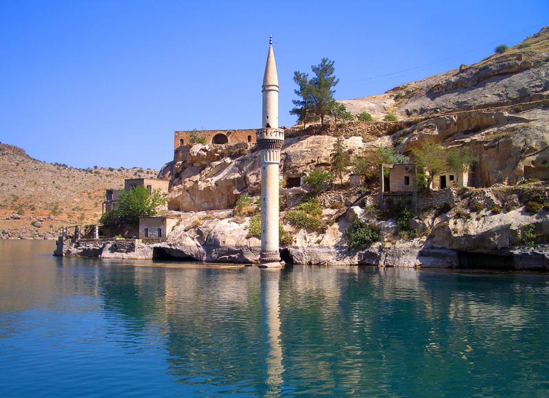
The rising water of the Atatürk dam generated the third largest lake in Turkey and submerged 191 archaeological sites. (Wikimedia commons)

It is widely agreed that in addition to water reserves, massive hydraulic infrastructures provide different types of benefits, such as the production of electricity, increased farmland brought by irrigation as well as developments of fishery and water-related industries. However, in addition to their maintenance costs, the construction and up-filling of dams entails potential political international issues when built on rivers flowing through different countries, the dislocation of thousands of people, the permanent loss of the best soils and the widespread destruction of both cultural and natural heritage. In the face of these permanent losses, dams have a finite lifespan ranging between 50 to 120 years.

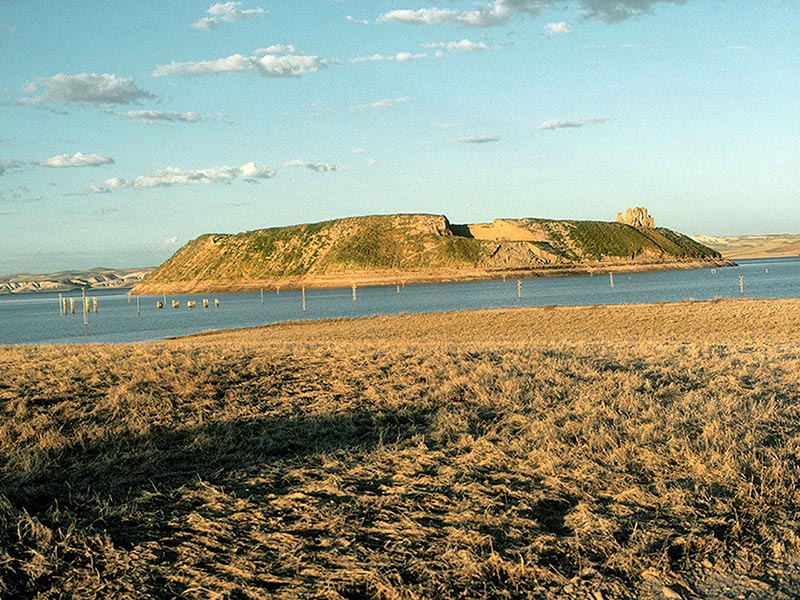
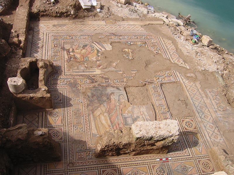
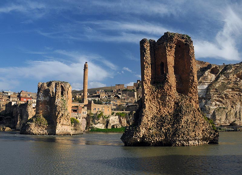
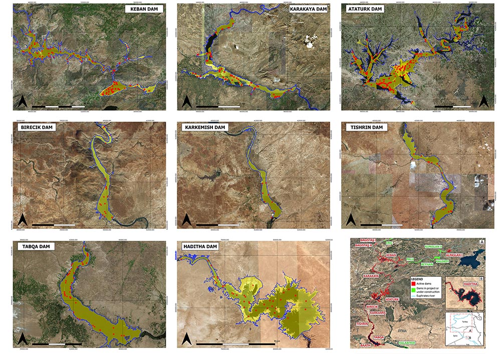
Despite the concerns regarding the benefits and costs of dams, Middle East and North Africa (MENA) countries today are witnessing an ever-growing number of large-scale hydraulic infrastructure projects. New dams are being built in Turkey, Iraq and Iran, as well as in Egypt, Sudan and Ethiopia. Turkey represents one of the most relevant examples where development has often deeply threatened or damaged cultural and natural heritage. Since the late 1960s the construction of dams throughout the country caused the total or partial flooding of important ancient sites such as the Bronze, Iron, Hellenistic, Roman and Byzantine capital city of Samsat, the Roman city of Zeugma and the medieval towns of Hasankeyf and Halfeti. Today more than 600 dams are active in the country and almost 200 are under construction or in planning stage.

The main mound of the ancient city of Samsat in the process of being submerged by the raising water of the Atatürk dam. (Wikimedia commons)
Zeugma, 2002 rescue excavations in the House of Quintus Calpurnius Eutykhes. Triclinium with the mosaics of Achilles at Skyros (above) and Theonoe and Leukippe (below) dating from the 2nd-3rd centuries CE. (courtesy of CCA - Centro di Conservazione Archeologica)
The piers of the mid-12th century C bridge still standing in the Tigris river at Hasankeyf. The piers are expected to be flooded once the Ilısu dam will be fully operative. (Wikimedia commons)
The mid-12th century CE minaret of Halfeti partially submerged in the late 1990s by the water reservoir of the Birecik dam. (Wikimedia commons)

Despite these enormous losses, and while a lively debate took aim at both the expected outputs and the issues concerning land loss and resettlement, less attention was given to the impact of dams on cultural heritage. Archaeologists often avoided political stances, largely because they get their excavation permits from the same governments that are building the dams.

The OrientDams Project

The OrientDams initiative started in 2015 with the aim of quantifying the loss of archaeological heritage due to dams. It brought together a team of archaeologists and engineers from the University of Bologna directed by N. Marchetti, under the wider EU-funded JPI project "HeAT – Heritage and Threat" based at the University of Copenhagen with I. Thuesen as its coordinator, which aimed at systematically analyzing threats towards cultural heritage as well as developing tools and strategies to confront them.

For the scope of the OrientDams project we considered three rivers that played a key-role within the history of the MENA region: the Euphrates, the Tigris and the Nile. Thirteen existing dams and six in project were analyzed along the Euphrates and Tigris rivers from their northern springs in the Anatolian mountains, passing through the Syrian and Iraqi steppes down to the southern Mesopotamian floodplain. In Egypt we investigated the real extent of the damage caused to the archaeological sites by the two Aswan dams on the Nile, which created one of the largest artificial basins on earth.

To do so, our multi-disciplinary team applied an integrated methodology including archaeological and geo-spatial open-access datasets, organized in a webGIS in order to foster data sharing and research replicability. Archaeological data were retrieved from published report of surveys and excavations in dam reservoir areas, as well as from the webGIS TAY project, which provided georeferenced shapefiles of several archaeological sites in Turkey.

The OrientDams webGIS showing the distribution of dams in MENA countries. (https://www.orientlab.net/orientdams/orientgis-map/)
The research methodology of the OrientDams team. After collecting all the available archaeological and geographical information, these have been processed in a GIS. The result shows the extent of damage to the archaeological sites caused by the increase of the water reservoir through time.

Geographical data included various spatial datasets and georeferenced satellite imagery. The former were acquired from the official websites and GIS platforms from the Turkish Ministry of Forestry and Water Affairs and the Food and Agriculture Organization's "Aquastat project", both of which provided the bulk of information for dams and water reservoirs. The second group of geographical data was collected from the US Geological Survey EarthExplorer website and consisted of multi-temporal satellite imagery taken since the 1970s until today, which were processed to reconstruct the extension of the water reservoir of the dams through time.

Download File: http://www.asor.org/wp-content/uploads/2020/12/Fig.-8.mp4?_=1

The multi-temporal evolution of the Keban dam reservoir obtained by overlapping different Landsat satellite imagery from the 1970s until 2016.


By cross-correlating the archaeological sites in surveyed areas with the extensions of the water reservoirs, we were able to precisely determine the number of sites actually submerged by the dams through time. As a result, the team identified almost 2500 archaeological sites along approximately 1300 km of the three rivers flooded by dams. This datum is even more striking when considering that their number is most likely an incomplete one, as large parts of the reservoir areas have not been systematically investigated by the archaeologists.

The impact of dams along the Euphrates river. From north to south the eight most destructive dams are shown, five in Turkey (Keban, Karakaya, Atatürk, Birecik, Karkamış), Syria (Tishrin, Tabqa) and Iraq (Haditha). Red dots indicate archaeological sites, the blue lines represent the water reservoirs extensions, while the yellow surface shows the extension of the archaeological survey areas.

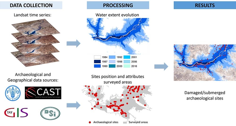
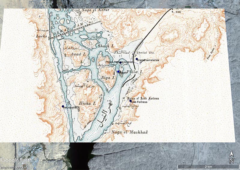
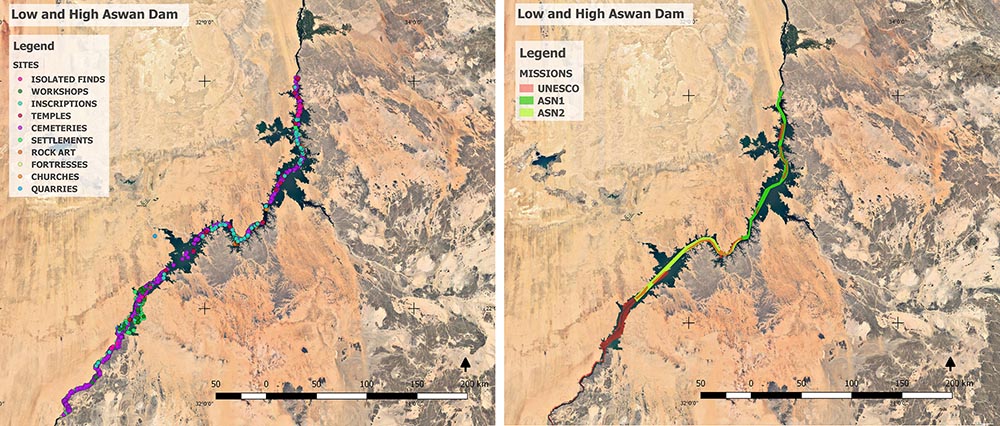
One of the most striking results was highlighted by the study of the Aswan dams. Indeed, while the public and most of the academic community have in mind the spectacular rescue of several monuments at Abu Simbel and Philae, most archaeological sites were totally neglected or only poorly documented. In order to provide a comprehensive picture of the damage caused by the Aswan dams, the OrientDams team systematically collected all the available documentation about the archeological researches prior to the construction of the dams.

In total 1753 flooded heritage sites were identified, including 781 ancient cemeteries, 392 settlements, 289 rock art places, 103 temples and churches. The research also revealed that only half of the total reservoir area (52%) had been surveyed, thus suggesting a remarkably higher number of archaeological sites lost under the water of Lake Nasser.

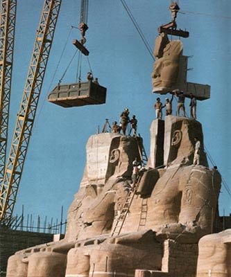
The reassembling of the statue of Ramses II at the Great Temple of Abu Simbel in 1967 after having been moved in order to save it from the Aswan dam flooding. (Wikimedia commons)

Investigating the real impact of the Aswan dam on the archaeological sites by georeferencing in a GIS software an old map with the location of several ancient sites.
The impact of the Aswan dam on the Egyptian cultural heritage. To the left, the location of the different types of heritage places (1753) submerged by the water reservoir. To the right the extension of the area surveyed by archaeologists corresponding to 52% of the Lake Nasser area.

A Systematic Safeguarding of Archaeological Sites Threatened by Dams: A Story yet to be Written

Our research provided an unprecedented overview of the destruction of the cultural heritage perpetrated along some of the most important rivers of world history. The results of these researches are now available through our webGIS, together with the open-access scientific and more popular papers.

The research conducted by the OrientDams team would ideally contribute to raise awareness on the issue of endangered heritage due to development projects, such as dams, and on the related needs of documentation protocols and strategies.

To date, activities and projects aiming at protecting the archaeological sites and monuments are generally missing or only partially included within the master plans for major dam projects. For example, the great number of dams currently under construction in Turkey is not paralleled by an equal number of survey and rescue excavation projects. In this regard, several scholars around the world stressed the need for strategies and working protocols to document and safeguard archaeological sites and monuments in the planning of hydraulic infrastructures at international, national and local levels. Funders of development works, foremost the World Bank, should review their current policies, which offer insufficient protection to cultural heritage.

We hope that more studies about the impact of dams and large infrastructures on cultural heritage worldwide will appear soon, for the benefit of both policy-makers and the general public, especially in balancing long-term costs and advantages (thus far insufficiently evaluated) in order to implement more effective safeguarding policies and more sustainable development projects.


Nicolò Marchetti is a Full Professor of Archaeology of the Ancient Near East at the Department of History and Cultures, University of Bologna, Italy. He directs excavations at Karkemish in Turkey and at Nineveh in Iraq and is the scientific editor of www.orientlab.net.

Federico Zaina is Research Fellow in Archaeology of the Ancient Near East at the Department of History and Cultures, University of Bologna, Italy. He is a Shelby White and Leon Levy grantee at the Polytechnic University of Milan.


Further reading:

Marchetti, N., Bitelli, G., Franci, F. and Zaina, F. 2020. Archaeology and Dams in South-eastern Turkey. Applying Post-Flooding Damage Assessment to Improve Current Documentation and Safeguarding Strategies on Cultural HeritageJournal of Mediterranean Archaeology 33.1 (in press).

Marchetti, N., Curci, A., Gatto, M.C., Nicolini, S., Mühl, S. and Zaina, F. 2019. A Multi-scalar Approach for Assessing the Impact of Dams on the Cultural Heritage in the Middle East and Northern Africa, Journal of Cultural Heritage 37: 17-28.

Marchetti, N. and Zaina, F. 2018. Documenting Submerged Cultural Heritage. Dams and Archaeology in South-eastern Turkey. In M. Kinzel, M.B. Thuesen and I. Thuesen (eds.), Culture and Conflict. Understanding Threats to Heritage, Copenhagen, Orbis: 28-35.

Click here for a PDF of this article. 

No comments:

Post a Comment